Monday 16 December 2013

Two more mountains

Little Mount Peel, 8 December
Turns out to be not very little at all. We drive down the day before planning to stop the night in Geraldine, but also to meet up with Brahm, Mike's old work buddy, for lunch who's living and working in Timaru. We've passed through Geraldine before but not stayed there and the Backpackers turns out to be pretty good, converted from an old maternity hospital.

Mike and Paul beside a stream at the foot of the mountain


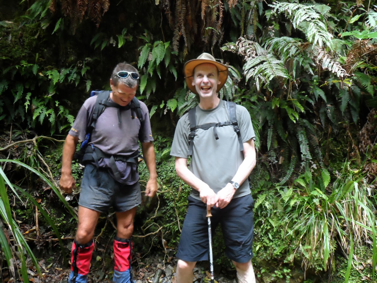
We set off pretty early and the weather's not looking too bad though there's a chance of rain later on. Before we start the walk we bump into Paul, a Kiwi tramper, who's doing the same as us but planning to go up the longer 'more interesting' way. He obviously has a lot of experience and certainly looks like he knows what he's doing so we join forces with him.

Following the ridge up to the peak, still visible before the cloud arrives


He leads us over and along streams right at the start of the walk and I begin to wonder if we've done the right thing. However he's a nice chap and he likes to talk but has difficulty walking and talking at the same time, so there are a lot of rather unnecessary stops and all the time the clouds are gathering as the weather begins to turn.

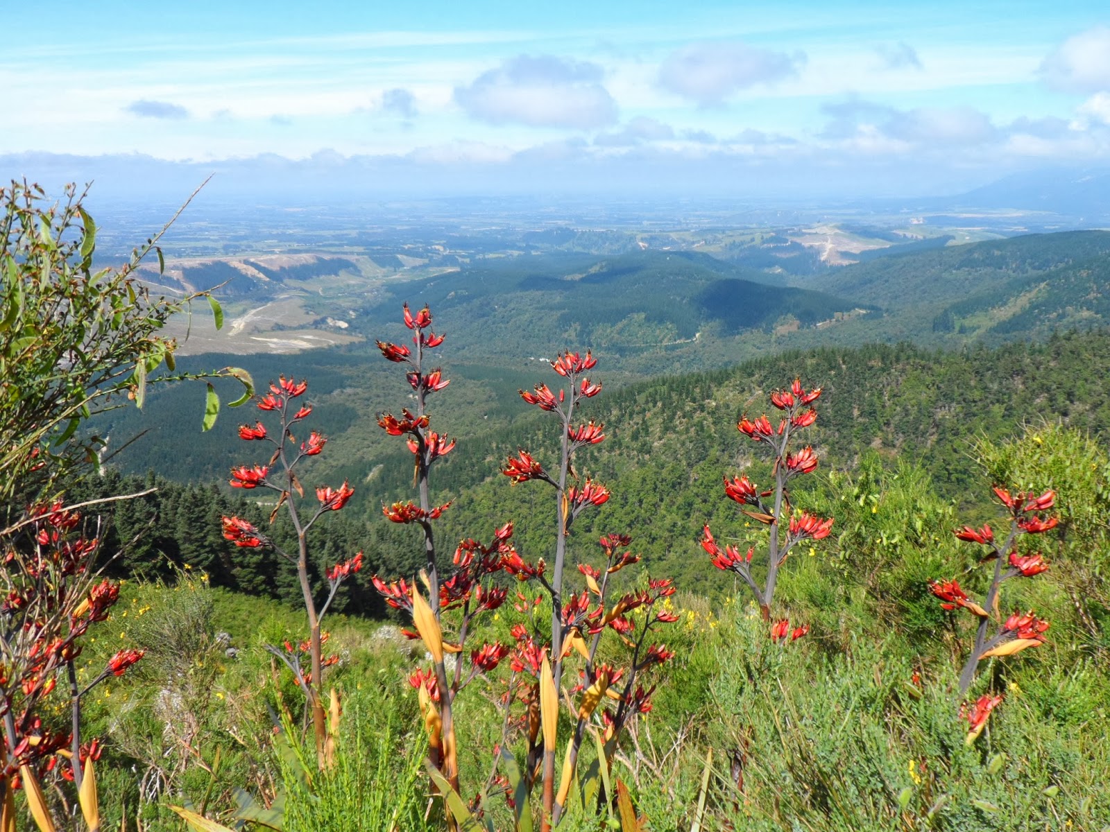
Looking through the flax back across the Canterbury plains


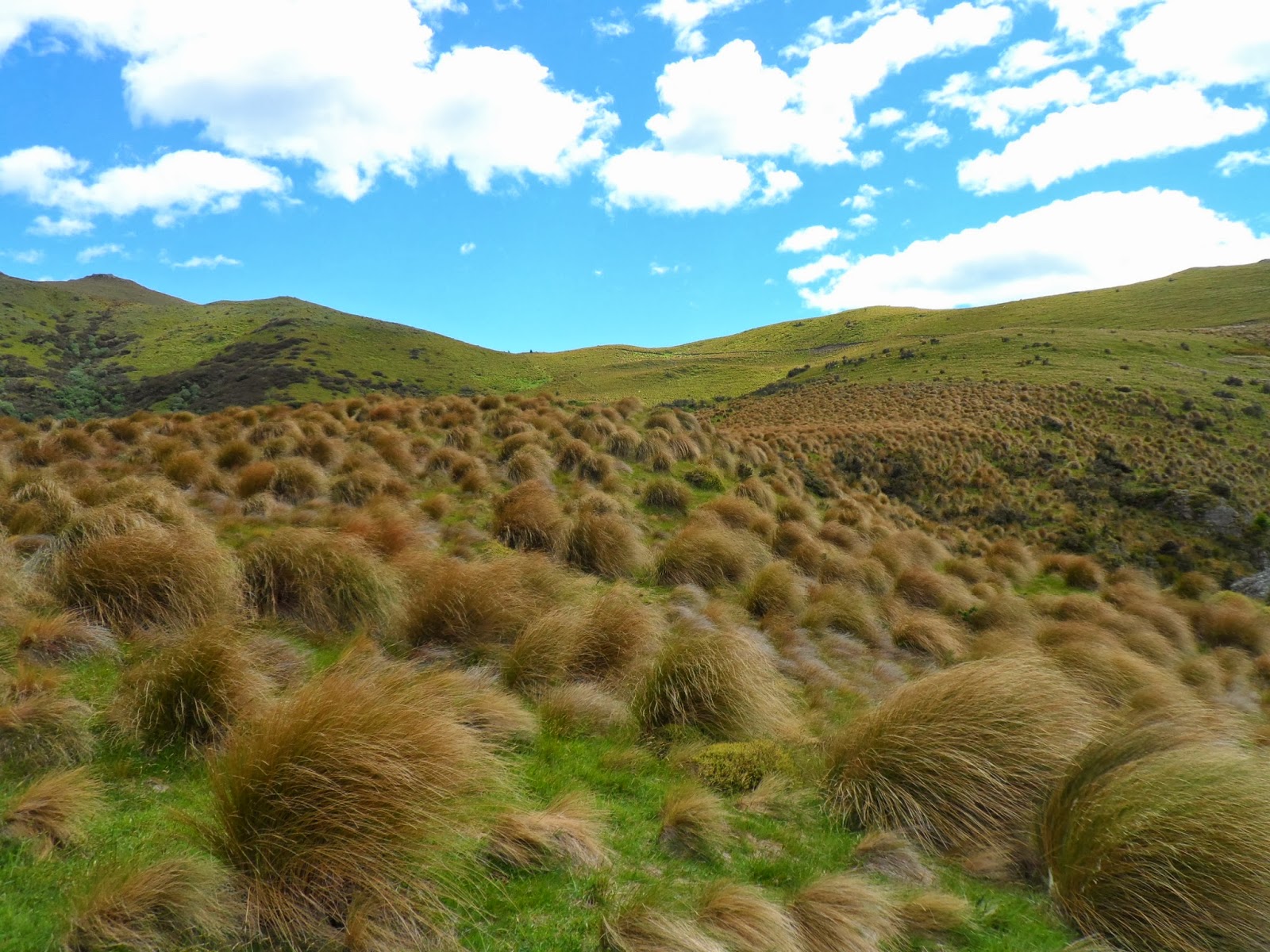
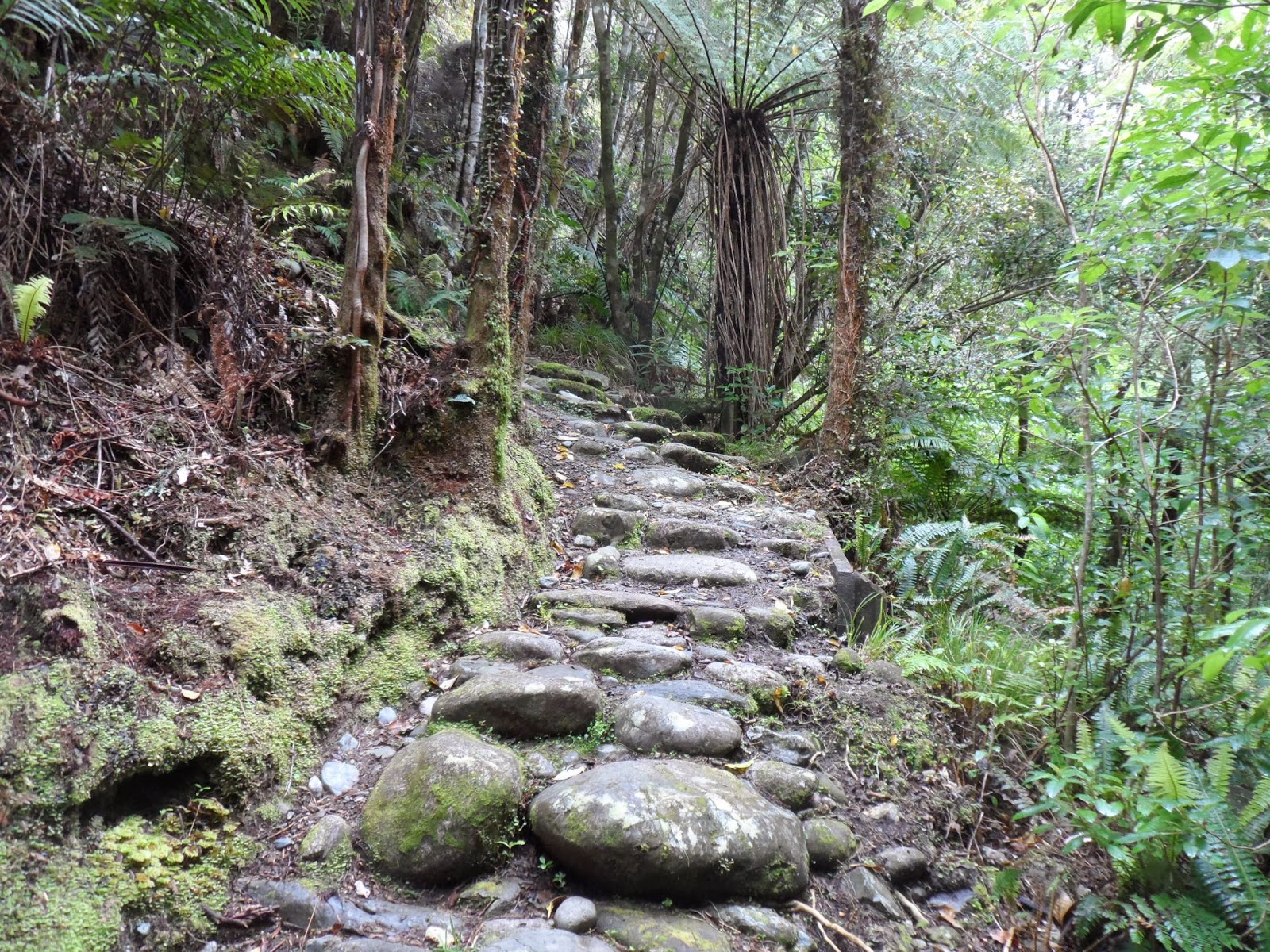
We know it's a long walk. The DOC boards say 3.5 hours up the long way and 2.5 the quick route. We eventually climb out onto a ridge, walking through huge clumps of flax and spiky Spaniard. Initially we can see the top of the mountain but as we get closer, thick grey cloud floods in over the saddle and envelops the peak. The track itself is pretty clear but not at all easy, involving some huge leg-stretching steps and, towards the top, some rock climbing. 'Nothing difficult, so long as you maintain 3 points of contact at all times' says Paul. By this time I'm really tired and the slight drizzle turns into rain. At the top we can't see anything at all.

Following Paul up the rock face, Mike behind ready to catch me

We have lunch in the hut just below the summit then begin the descent down the 'easy' path. To begin with there are a lot of board walk steps and as they're wet we really have to concentrate. It's certainly quicker going down but still takes about 2 hours, so just over 6 hours in total. We are wet through and I have to pour the water out of my boots. It takes 4 days for my legs to recover, but I'm quite proud of myself, good practice for the Routeburn!


Mount Grey, 15 December


Huge flax surround the pool with dragon flies skimming the surface


Not such a high mountain, this one, so should be a doddle after Mt Peel, but it's a very warm day so could be a struggle. We start off planning to do the Grey River Nature Trail, and are definitely on the right road, but somehow we miss that and end up at the foot of the Mt Grey trail. Just as we're having a look around the lake at the start of the walk, 5 or 6 other cars arrive altogether, planning to climb the mountain, so we do it too.

Fabulous foxglove path


Starts off through a lovely shady pine forest and then as we come out into the dappled sunlight we find ourselves on the most gorgeous woodland trail edged by huge quantities of foxgloves. The path continues upwards eventually coming out into full sun as the upper part of the mountain is covered with broom and manuka. We're getting pretty hot but the lookout is within sight and when we get up there I sit for a long time in the cool shade before heading back down the same way.

Looking through the flax northwards


Just a short walk, 2 hours at most so we go to Amberley for lunch, take a look at the local beach and make our way home.

Washpen Gorge

8 December 2013
This is a really interesting and varied walk on private land, taking about 3-4 hours. The owner joins us at the start to give us leaflets and information. We begin walking through a pine forest and then come out onto a path beside a gorge.

The sides of the gorge rise above us as we make our way along the footpath

We continue climbing and eventually reach a lovely tussock upland area and follow the path down again into the gorge. The owner’s done a lot of work building steps and bridges to create this circular walk. He makes a $10 charge for the upkeep of the path.
 

Beautiful upland tussock grass


Coming down to the pool at the foot of the waterfall
 
At the lowest point there’s a waterfall plunging into a pool and we’re able to cross the stream and come out into a lovely valley bottom below overhanging cliffs. The vegetation is all native trees and plants.

 
Beautiful native greenery

We soon come to the lake which he’d mentioned as a good lunch spot. What he failed to mention is that the place is sandfly infested, so I have to eat my lunch walking round the lake rather than seated at a picnic table. They don’t bother Mike as he’s helped himself to the insect repellent spray on the table, which I can’t bring myself to use because it smells so dreadful. When we get back to the car we are attacked again and spend a lot of time slapping our legs to get rid of the little black monsters.
 
Picnic area beside the lake all set up for group visits, all we saw were sandflies
 

Hokitika

14 November
It's a long w/e here in Christchurch and the weather's not looking too bad so we decide to make the trip over to the west coast. It rains quite a lot that side of South Island and we’ve been waiting for decent weather before making the trip. We set off on Thursday evening once Mike finishes work planning to stop this side of the Alps in Springfield having booked ourselves into Smylies on our new YHA cards. Not exactly sure what’s happening about food but as the hostel is run by a kiwi man and his Japanese wife we’re hoping Japanese food might be available.

The hostel itself is rather nice. We’re in Narnia room (so-called because we have to go enter through a wardrobe door). Kiwi hostels all seem to have double rooms some with en suites so quite comfortable. Works out much cheaper than a normal b&b and they’re very sociable places. The rumour of Japanese food was correct and we get a lovely dinner for $10 each!

Wild lupins beside the Waimakariri on the way to Arthur's Pass

 
15 November
We head off towards the mountains next morning planning to stop for a walk somewhere near Arthur’s Pass,  the village by the mountain pass. We walk up the Otira Valley for a few hours, starting off with the Dobson’s Nature Walk which takes us over boardwalks through tussock grass, with masses of Mount Cook lilies and other wild flowers. It becomes quite a narrow stony path and we end up by a small bridge which takes us across a torrent , where we stop for lunch. Any further walking is for experienced mountaineers according to the sign.

Mt Cook lilies beside the boardwalk


Next stop is Arthur’s Pass village for coffee then we head on down towards Hokitika. Driving up towards the Pass we’re travelling through beech forests but once we begin to descend the other side the vegetation changes completely and we’re in native bush, back to tree ferns and lush green vegetation. All that rain I guess. We find our hostel, Birdsong, and book in. It’s another rather individual one run by an English couple, though unfortunately it’s a little too far out of town. That evening we walk in along the beautiful wild beach collecting pebbles. It’s a long hike with an empty stomach but eventually we make our way to the chippie where we bump into Brenda, one of my quilting ladies. Jolly good fish and chips. Tonight we walk up to the Glow-worm Dell. It’s pitch black and quite magical as the fairy lights of the glow worms twinkle in strings and patterns in the dark.

 
Rickety bridge at the top end of the Otira Valley


16 November
Next morning the weather’s overcast and rain threatens. We wander round the local market, buy some lunch and end up doing a series of short walks starting with a bit of coastal bush leading to a wild beach. Next is the Bellbird walk near Lake Mahinapua and then Hokitika Gorge, a major attraction round here. The river here is an extraordinary chalky turquoise in colour and we walk over a swing bridge to cross to a bank of rock.

Amazing blue of the river at the Hokitika Gorge


At this point it really begins to pour with rain, so while Mike wanders over the rocks, I beat a hasty retreat back up to the car. We end up seriously wet, but dry off on the way to our next walk, Lake Kaniere Water Race Walkway, and by the time we get there the sun’s coming out. The Race is a fast-flowing water channel built originally for use in gold mining but later to produce electricity. It makes for an interesting walk though we don’t have time to do the whole thing.

The Victorian water race stretches for about 12 km south from Lake Kaniere


We get a taxi into town and have a disappointing meal at the Cafe de Paris. Hokitika is a town built in the gold rush days back in the middle of the 19th century. It’s now famous for it’s greenstone and has a lot of art & craft shops.

17 November
Goldsborough is recommended to us by the hostel owners so we take a diversion on our way back to Christchurch. It was a town that grew out of nothing in the heart of the bush when gold was discovered there in the 1840s. We do a fantastic walk through and above the gold workings. It’s very atmospheric and evocative of this bygone era when men would struggle on foot through dense bush and set up mining and panning for gold. The town disappeared almost as quickly as it had grown when the gold dwindled.

Footpath in the old gold-mining district by Goldsborough
 
We drive back through Arthurs Pass stopping for a walk up to the Devil’s Punch Bowl. We’re back into beech forest now we’re west of the main divide, and lower down we walk through these forests to Turkey Flat in the valley bottom where the Waimakariri river flows its windy way.

Beech forest at the devil's Punch bowl, west of the main divide